
Civic Science Observer
“Science is something that we do together.” Benjamin Richards on how OceanEyes collaborates with citizen scientists to monitor deepwater fish in Hawai’i
“Any individual image is going to be annotated or looked at by 15 independent volunteer citizen scientists.” — Benjamin Richards
In Episode 6 of Season 1 of Science Engaged, I speak with Dr. Benjamin Richards. He is the senior marine scientist and research mentor for the OceanEYEs participatory science project as part of the National Oceanic and Atmospheric Administration, or NOAA Fisheries. Dr. Richards discusses how NOAA researchers use deep-sea camera systems to monitor fish populations in the Pacific, particularly deep-water snappers and groupers. The specialized camera systems descended into the seafloor and recorded thousands of images throughout the course of the survey, resulting in a wealth of data that would’ve been overwhelming for the scientists to analyze themselves.
Thanks to the contribution of more than 30,000 volunteers, the OceanEyes team of volunteers have now identified more than 260,000 fish species in the Hawaiian waters. Under Dr. Richards’ leadership, the program, which is run through the Zooniverse platform, has expanded from Hawaii to Guam and the Northern Mariana Islands, with plans for American Samoa.
Dr. Richards highlights the importance of community engagement by including people from all walks of life to make science more accessible and impactful. He emphasizes the importance of providing meaningful, engaging, and user-friendly projects for volunteers as ways to retain participation.
This episode is made possible by support from Schmidt Sciences and the UC Santa Cruz Science Communication Catalyst Grant.
Here is our conversation:
Kristel Tjandra: Welcome to Science Engaged where we explore why and how scientists partner with diverse communities.
Benjamin Richards: Because science really is something that we do together. It’s not us as scientists and them as non scientists. Scientists. Science is just asking questions and figuring out a process to find the answers, and that’s something we do together.
Tjandra: And today I’m joined by our guest, Dr Benjamin Richards. Dr Richards is a senior marine scientist at the Pacific Islands Fisheries Science Center, which is part of the National Oceanic and Atmospheric Administration, or NOAA Fisheries. He is currently based in Honolulu, Hawaii, where he and his team monitor the distribution and abundance of fish population in the Pacific to help guide management in commercial fishing. Today, we’ll hear from Dr Richards about a citizen science program he directs called OceanEyes. Dr Richards, welcome to the show.
Richards: Thanks, Kristel, it’s a pleasure to be here, and I really look forward to engaging with you and your listeners out there in the community.
Tjandra: Dr Richards, tell me a bit about yourself. What is your background and how did you get into ocean science?
Richards: So I started out being interested in the oceans, in the marine environment, from a really young age. It’s probably completely cliche, but I was of the generation that grew up with Jacques Cousteau and all of that. So I always wanted to explore the underwater world. I remember getting scuba certified at a quarry in Texas when I was about oh, 14 or 15 years old. And it just kind of continued from there throughout high school, I was always interested in the sciences. When I graduated high school, I was kind of 5050, whether I was going to go into biology or physics, and decided that I wanted to spend more of my life outdoors rather than indoors. So kind of went the biology route.
Tjandra: Yeah. Can you tell me a bit about the work you currently do in Hawaii?
Richards: Yeah. So I’m a researcher with the Fisheries Research and Monitoring division out here at the Pacific Islands Fisheries Science Center. And our mission is to collect and create the best scientific information available on Pacific Fisheries stocks, to provide that best scientific information available to the managers to make good management decisions to ensure sustainable fisheries.
Tjandra: How did your research work or career led you to OceanEyes? How did it start? And you know, how long has it been around?
Richards: Yeah, it’s a really fun story. So I, I started out more in the the coral reef world. I was a research diver for many, many years, starting out with the Florida Keys National Marine Sanctuary right out of undergraduate school. And then I moved out here to Hawaii in 2004 and started work on my graduate degree, and then also working with NOAA Fisheries on monitoring the distribution of large bodied reef fish throughout the Pacific. So got to travel to all of the US jurisdiction islands throughout the Pacific. So that’s Hawaii, the Northwestern Hawaiian Islands, Guam Saipan, Commonwealth of the Northern Mariana Islands, American Samoa, and then all the Pacific remote island areas, Johnston Atoll, Palmyra Atoll, Jarvis Island, Howland Baker, you know, you name it. And so, you know, we would do the standard we would go diving at, you know, predefined survey locations with our underwater clipboard and our underwater paper and pencils and, you know, writing down and collecting all the data that we needed to help provide scientific information on those reef fish species. And that was fantastic. And then about 2011 I got asked to join the the stock assessment program and the Fisheries Research and Monitoring Division here at NOAA Pacific islands and to help develop a fishery independent survey for deep water bottom fish. So when I say deep water bottom fish, I’m talking about really six species of deep water snapper and one deep water grouper that are economically and culturally important to the islands of Hawaii. They’re, they’re the really, you know, pretty red fish that you see on, you know, high end menus are really important around the holidays. So they’re really an important fishery here in Hawaii. And then they are shipped out of Hawaii, you know, to the US mainland. And. And elsewhere. And NOAA Fisheries is mandated under the Magnuson Stevens fisheries conservation and management act to do stock assessments for all federally managed species. And these stock assessments are basically just very prescriptive ways that we collect scientific information on fish populations, do some mathematical modeling, make predictions about, you know, how many fish are likely to be out there in the ocean in years in the future. And so therefore, what sustainable catch levels, sustainable commercial catch levels, can can be to ensure both the economic livelihood of our fishing community, as well as sustainable fisheries for the community into the future. And so I came over and started working on that, and we kind of developed a survey for this particular fish stock. And part of that survey involved underwater camera systems. These fish live much deeper than we can go as divers, you know, they’re generally down at the 75 to 400 meter depth range. So thinking like, you know, 900 1000 feet, you know, things like that, so much deeper than divers can go. And we still wanted to to get some some optical information about the the fish population down there, so we paired a deep water camera system with our traditional hook and line fisheries surveys. So we get some information about, you know, behavior, about some of the fish populations that might be down there but might not be hungry at a particular time, not taking a hook, or things like that. And so that was really cool. So we developed this new deep water camera system with some partners that we called the mouse, the modular optical underwater survey system. Just because we’re the government, we have to have an acronym for everything, and so it’s really cool. So it’s a camera system that has two camera heads, so it has binocular vision, just like you and I. It’s a black and white camera system so it’s super light sensitive, so we actually don’t need to use any artificial lighting. We can use just the tiny little bit of sunlight that gets down there to the bottom, and we can, you know, record video of all the fish populations. And because it has binocular vision, you know, we can not only see the fish, figure out what species they are, we can calculate the distance to each fish, and through that, the actual size of the fish. So we can identify the species, we can count them, we can measure them, get all the scientific information that we need. Now that’s great, but video data is just video data. We need to turn it into numbers for data, and it takes a long time to go through all of the video data. We had a bank of four analysts that would take about three months to get through all of the video data from one survey. So we had the idea of, hey, we know about some of these crowdsourcing projects. We’ve seen some of these other projects through the Zooniverse portal and some of the other portals where citizen scientists can engage in some of these interesting projects and help us process some of the data. So we I worked with, actually, a undergraduate college intern that I had one summer, and her project was to develop the user interface for what became OceanEyes, which is the portal that we use to house all of the images that are collected by the mouse camera system. Up in a Citizen Science portal, there’s a really nice tutorial. There’s a really nice field guide that walks as a scientist through the process of identifying fish in a particular image, figuring out what species they are, localizing where they are in the image, you know, putting a little.on their nose and a little.on their tail, you know, so we can kind of see where they are. And through that, we can get some of the species counts that we need for our science, and we can give back to the community in terms of, you know, providing some imagery. They can see the underwater fish populations, you know, that they may be fishing. They can see what the habitats look like. They can learn more about fisheries management. So it’s been a real fun and engaging, you know, back and forth conversation, because science really is something that we do together. It’s not you know us as scientists and you know them as non scientists. Scientists. Science is just asking questions and figuring out a. Process to find the answers, and that’s something we do together.
Tjandra: Yeah, yeah. That’s a that’s a very important point. And you know, you mentioned so many beautiful places you’ve you’ve been to. I was wondering, you know, when it first launched, did you have a particular place in mind to launch the the program? Did you? Did you focus only on Hawaii, or also all these places.
Richards: Yeah. So starting out, we focused on Hawaii. We started developing the bottom fish survey. We started developing it specifically for the bottom fish populations here in Hawaii, just because that was our our highest management importance at the time, and since we were going to be developing the survey, it was logistically most feasible to develop it locally, where we could easily be going back and forth from the field to the lab and things like that. Since that time, we’ve begun expanding the bottom Fish Survey to include not just Hawaii, but we now have an operational bottom Fish Survey in Guam. We’ve completed a pilot project in the Northern Mariana Islands. And then June of 2026, we’ll be going down to American Samoa kickoff project there.
Tjandra: Yeah. And these are all. These are all under OceanEyes as well.
Richards: So not not yet. These are just the pilot projects, so there won’t be any data from them going into OceanEyes yet. But we are also working with our colleagues at the southeast Fisheries Science Center in the Gulf and South Atlantic. That science center is headquarters in in Miami, Florida, and they deal with some of the same types of deep water snapper species there that we have here. And they use very similar camera systems. When we develop the camera system, we developed it for NOAA Fisheries, not just for the Pacific Islands, so they’re actually duplicate camera units at many of the other fisheries science centers across the country. And so we’re working with them to figure out how we can ingest some of their data into OceanEyes, if that would be useful for them and their program. So we’re working down those lines, trying to make OceanEyes as useful as possible for as broad a community as possible.
Tjandra: Yeah, so for for people who are not familiar with Zooniverse, so you mentioned this platform called Zooniverse, where OceanEyes is kind of based off, yeah. Can you describe how it works and how citizens or people can access this platform.
Richards: I can, yeah, Zooniverse is one of many crowdsourcing citizen science platforms available. We chose it just because I happened to meet one of the scientists from Zooniverse at a scientific conference, and we had a great kickoff and really fun brainstorming session about some things that we could do together. And they had, at that time, just developed a user interface, for lack of a better word, that they called panoptes, which allowed researchers like myself to set up citizen science projects without the need for a whole lot of back end coding and things like that. So it made it really, really easy. So I don’t want to suggest, you know, Zooniverse is better than any other platform out there, but it’s the one that worked for us and we chose and what it provides is a website, a web platform for researchers to host citizen science projects put up some data that they need some help analyzing or processing. And Zooniverse works with us to kind of fine tune some things here, fine tune things a little bit there, and then, when the project is ready to go, it gets launched on the Zooniverse website and immediately is accessible by their volunteer user base, which is currently, I think, several million members. So in terms of getting the word out, it really helps. And through the platform, citizen scientists, people who are interested. When I say citizen scientists, it’s really just anybody out there community that has interest. You don’t have to have any special qualifications. They can engage with any of the projects. Go through the tutorials, you know, figure out what’s being asked, and start helping and learning about the data and the background of each particular project.
Tjandra: Yeah, so I’m curious. You first created OceanEyes, what were some of the goals? What are the things that you want to achieve through that project,
Richards: We had several goals in both in terms of producing scientific information for education and outreach or broadening the conversation with the community. So I’ll kind of go through all of those. You know, of course, one of the goals was, how can we get all of this, you know, image data processed as quickly and efficiently as possible? And thankfully, you know, humans are pretty good optical processors. We can recognize things in pictures pretty easily. You know, computers are getting better and better, and AI algorithms are getting better and better, and I’m sure we’ll talk about that a little bit later. But when we started, humans were still much better at processing imagery. And so we thought, hey, you know, if we can put all this imagery up there, get a whole bunch of people, you know, excited and engaged and clicking around and identifying fish, you know, then, then maybe we can get this data processed, you know, quicker and more efficiently than just having, you know, a bank of graduate students sitting in dark rooms all day long, looking at black and white video, and that worked really well. And simultaneously, one of our goals was also, hey, we have all this cool, interesting information. Are there other ways that we can get it out there to the community? Scientists are great at publishing scientific research papers in scientific journals, but I would hedge that most general members of the community don’t read through scientific journals all that frequently. So are there other ways that more exciting, ways that we can get some of this information out to the community in an engaging way, where they can be part of the process that’s always a big thing for us is, how can we get the community to be, to be part of the scientific process, from concept to completion, you know, not just, you know, commenting on the results or, you know, something like that, but really being part of the process. And that’s been really exciting, that that back and forth conversation between, you know, some of our researchers here and some of the really engaged volunteers, one of the things that the citizen science platforms provide is a chat channel and a mechanism for Back and Forth conversations, both amongst volunteer members of the of the community and between volunteers and scientists here at the Science Center, yeah.
Tjandra: So earlier, you mentioned about these binocular this, this high tech camera that can, you know, snap pictures down to, I think you said 1000 meters. Was that, right?
Richards: You can go down to about an ambient light, about 200 meters, two meters, meters on a really good day, right?
Tjandra: Yeah. So, how do citizen scientists contribute, I guess, to the data collection is because, you know, not many people have cameras like that that can snap pictures, yeah, yeah.
Richards: So, so that’s, that’s a little bit more limited, you know, just because, you know, in order to put a camera in the water, you have to have a boat, and it’s, you know, it’s a fairly small camera, but it’s not tiny, so you have to have, you know, the the all the equipment is very to, you know, mainly, lift it back up from the sea floor. So the primary mode of public engagement is through processing of the imagery and identifying fish in the imagery. Now we do when we do put the cameras out in the water, when we have put the cameras out in the water, we do partner with members of local fishing community. And so when we first started out, we were deploying the cameras using NOAA research vessels and things like that. But really starting in 2019, 2020, we started putting the camera systems on some of the commercial fishing vessels that we work with to actually do the data collection from the survey. So they’re the ones that go out and do the standard hook and line sampling. And in 2020 we started having that working with them to deploy the camera systems as well. So since 2020 we haven’t been deploying the camera systems off of NOAA vessels anymore. We’ve been deploying them from from vessels in the community
Tjandra: So it sounds like there are two types of engagement that people can participate in. One is, you know, commercial fishing boats can have those cameras when they’re going out at sea. And then people at home, they can check out the images and help identify the fish,
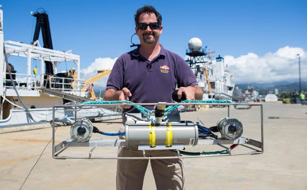
Dr. Benjamin Richards and NOAA researchers use a specialized camera system for the OceanEyes project to monitor bottomfish population in Hawaii (credit: Benjamin Richards/ NOAA Fisheries)
Richards: Correct, yeah. And, you know, in terms of the boats going out of water, you know, they have to be part of the survey, so there’s some requirements and things like that. Yeah, yeah, manage expectations. It’s not just, you know, anybody with a, you know, with a boat, can, you know, grab a camera and go out, although, if they have their own cameras and are collecting information, we’d love to see it.
Tjandra: Yeah, got it. So I’m curious, you know, what is it about OceanEyes approach to citizen science that captures the interest of the public? You know what? Why do you why do you why do you think people are interested in participating, you know, spending hours of their precious time in data collection or identifying images and contributing to the project?
Richards: I think, you know, from my experience, people in general are innately curious. And you know, if there’s new things, you know, there’s always some attention, and through the OceanEyes project, we’ve been able to kind of open up a whole new realm that most people don’t really get to see all that frequently it’s below diver depths. There’s not a lot of ROVs or camera systems that go out there and put their information out there to the public. There are increasing numbers of them, Noah’s Okeanos Explorer and her ROV, go down to super, amazing depths and have really high definition, you know, color cameras. And, you know, I encourage anyone out there to search up, you know, NOAA ocean exploration on the web, and just check out the video feeds that they have, because they’re amazing, you know. And then, of course, many other organizations, you know, oceanographic institutes, you know, have similar things. So I think there’s that innate, you know, human curiosity, and especially when you know it’s it’s information about fish that you know people are seeing on their dinner plates, you know, seeing in the supermarkets, you know, that’s in their own backyard that they may have fished for. Just being able to see that with your own eyes, is really cool.
Tjandra: Yeah, what would you say is the main demographic of the people who participate in these activities?
Richards: It’s amazingly broad. So we have everything from elementary school groups who are using it as part of their classroom to you know, retirees. Who are, you know, just, you know, looking for, you know, yet another fun thing to do in their retirement. We have, you know, people from the United States. We have people from outside the US. It’s really been amazing to see the broad demographic, both in terms of age and occupation and nationality, much broader than we thought. Last time I checked, we had about 25,000 volunteers for this particular OceanEyes project, and the breadth of it, the level of interest has just been amazing
Tjandra: Yeah, so for, you know, project like this that has been happening for a number of years, it’s It must take some effort to make it sustainable. How is OceanEyes funded? And how do you make the project keep going for many years?
Richards: Yeah, it does take some effort, and most of that effort is keeping engagement. We want to keep it interesting for our volunteers. They’re donating their time. They’re donating their expertise. We want to make sure that, you know, we’re responding to their questions, you know, quickly, you know, so that they feel valued, because they are incredibly valuable to us. And so it’s, you know, keeping up on the chat channel, you know, responding to questions, uploading new imagery when it becomes available. You know, downloading the results and making sure that the results are are used for science. You know if, if volunteers are going to be donating their time to the project, we want to make sure that it’s for a useful cause. So we have, thankfully, the Zooniverse and many of the other citizen science projects make that fairly easy. It doesn’t take a whole lot of effort right now, it’s myself, one of my other colleagues, part time, and then a third colleague part time, just kind of monitor things. Now that it’s set up, it took about five or six people to get the whole thing set up, but now that. It’s running fairly well. It’s really monitoring those chat channels, responding to questions, uploading new imagery, things of that sort. So that’s how we keep it sustainable, is by keeping it new, keeping it interesting, being engaged, and making people feel that what they’re doing is important, because it is.
Tjandra: Yeah, has there been any challenges in terms of securing funding or making sure that financially the program can be sustainable?
Richards: Not really. One of the really nice things about many of these citizen science platforms is we can use them at no cost to the government and no cost to the taxpayer. So we don’t pay a licensing fee to Zooniverse, so it’s really just our staff time that goes into maintaining the project. So it’s a really efficient resource for us, in addition to being really useful,
Tjandra: Yeah, so you know, one of the main concerns with any scientific research is data quality, and you’ve touched on this a little bit. How do you make sure that the data that people submit is valid? Is there a way to find out?
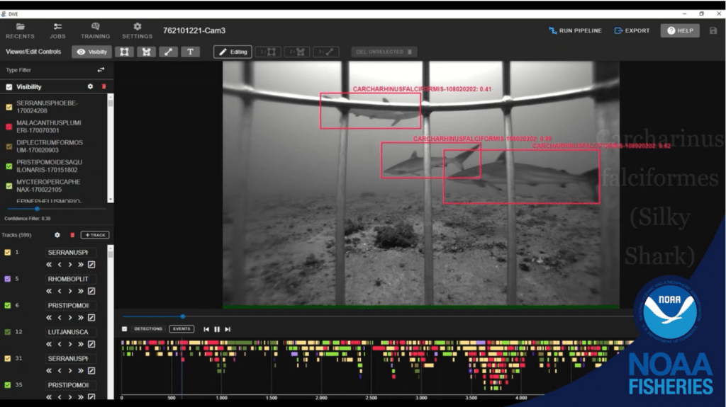
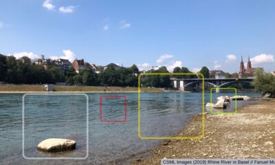
Citizen Scientists partner with NOAA researchers on OceanEyes project to analyze and annotate images taken from deep-water camera systems (credit: Benjamin Richards / NOAA Fisheries)
Richards: There is, yeah, there’s a really cool method that wasn’t developed by us, but it’s kind of become standard within the science, citizen science community, and in a lot of data gathering practices, which is multiple independent verification. So let me just walk you through a quick example, you know, with, you know, an image in question. So let’s say we, we have an image that came out of the mouse camera that’s now available on OceanEyes, and it’s presented out there to the community. So any individual image is going to be annotated or looked at by 15 independent volunteer citizen scientists. Each image will be, will be annotated by 15 different people, and then we create from that what we call a consensus annotation, where all of those 15 annotations are merged together. And if there’s a really high level of agreement, like all 15 people said, yes, there’s, you know, an alpaca Paka snapper, and it’s right here, up in the right hand corner. And everybody said that we’re like, great, there’s probably an apocalypse snapper up there in the right hand corner. And if, alternatively, we have another image. And you know, 15 people looked at it, and you know, five said that, you know, there’s an apaka pakka snapper up here in the right hand corner, and another five said, Oh, actually, down here in the left hand corner, and five others said, Oh, actually, it’s an Onaga. It’s not an O Paka. Paka. There’s not a lot of agreement. Then that image gets sequestered and looked at by one of our trained analysts to kind of figure out what’s going on. So we use that level of agreement metric, and over the years, we’ve kind of spot checked all along. In the beginning, we were checking every image to kind of figure out what level of agreement we felt reflected the accuracy that we needed for the data. So now any image that has a level of agreement above that threshold, but great, that’s good. Any image that has a level of agreement below that threshold, we go through and check. So that’s how we, you know, ensure data quality, you know, going into the future. And we have a publication that we put out on that kind of how we figure that out. And it’s really cool, because the citizen scientists you know that have been doing this for a while, you know, we have some volunteers that have done, you know, 1000s of annotations, and have become real experts. And so as we develop, you know, as those experts develop, we can also start having them spot check some of the images that have low levels of agreement. But people, people are amazingly good at doing a whole variety of things, and that’s one of the most rewarding things about the project.
Tjandra: Yeah, that sounds like a very systematic way of validating the data. I’m curious whether you know with AI, if data processing has changed for you and your team?
Richards: It’s starting to. Yeah, we started engaging on this problem with with AI and the AI community back in 2014 when NOAA Fisheries formed the artificial intelligence strategic initiative, which which I chaired from 2014 to 2018 roughly, and our charge was to help catalyze research and development in automated processing of underwater imagery for. For NOAA Fisheries, and since 2014 as your listeners will certainly know, the AI revolution has really exploded. But all of that AI revolution is predicated on the availability of training data for these deep learning and AI models, they have to have data to train on to be able to then make predictions based on that training data. And creating that training data is looking at images and saying, In this image, is this fish and it’s right here, and giving that information to the model to train on. So creating that training data requires a huge amount of human effort. So one of the really exciting things with the OceanEyes project is not only are we getting numerical data out of the images that we can use for our scientific information. We can actually use all of those human annotations as training data for our AI models. And so we are working very, very heavily on that. My colleagues at the southeast Fisheries Science Center in Miami have several machine learning, computer vision models that are getting really, really good at automatically detecting a number of different fish species in the Gulf, in South Atlantic and Caribbean. So that’s really exciting.
Tjandra: Yeah, that’s an exciting use of machine learning. And AI, I’m curious. You know, as a scientist, has working with the public change the way you see how science can be done?
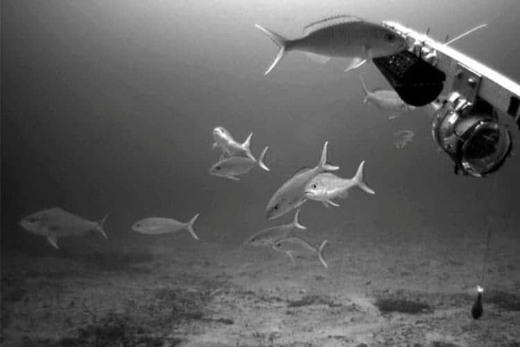
Fish species captured in videos collected by the NOAA researchers were identified with the help of citizen scientists (credit: Benjamin Richards/ NOAA Fisheries)
Richards: That’s a great question. I don’t think it’s really changed my view. I think it’s it’s probably enhanced my view. If I could say, you know, just of of, you know, how how willing people are to help, how engaged people can be if you provide them with a really high quality, engaging project, if you treat them with respect, if you value their time, you know, it’s really easy, you know, in the world of whatever age you know, become jaded and look at the, you know, the downside of things. And this is really renewed my sense of optimism and my outlook on on people and, you know, science and community involvement, yeah,
Tjandra: What do you think is the biggest value of involving the public in research?
Richards: I think the biggest value for me that I’ve seen is just that level of engagement, especially when I’m I’m doing science within an organization who’s whose job is to serve the public. It’s the it’s the taxpayers that fund everything that we do, and so we need to make sure that we’re providing that value back to the community and back to the taxpayer in every way possible, and being a good steward of the public resource and providing value, and this has really been a fun and engaging way to do that.
Tjandra: Yeah, for people who are interested in, you know, supporting projects like this, or starting one themselves. What advice do you have for them?
Richards: So the biggest advice that I have, you know, as always, is Think, think it through. Not just you know, what is this going to provide to me, but what am I going to be providing back to the people who are donating their time, and how to make it meaningful. Number one, in terms of people are donating their time, so make sure that you know what they’re doing is important and is going to have an impact and make it engaging, make it easy for them to get engaged with the project, learn what they’re supposed to do, have people ready to have that back and forth conversation, to provide support, to provide guidance, to provide encouragement, to answer questions. And and that’s, that’s basically what I what I would say, you know, make it meaningful, make it engaging, and be engaged.
Tjandra: Yeah, thank you for that before we close. Dr Richards, you know, if people want to find out more about OceanEyes or even get involved and contribute. It to the data image processing. How can they find you? Or how can they find your team?
Richards: Sure, so doing an internet search for OceanEyes, you know, once you filter through all the Billy Eilish things, then you know, you get to our project. Or if you search, you know, OceanEyes fish, OceanEyes NOAA, OceanEyes Zooniverse, what have you you’ll get the project description. You’ll get some information about the project. You can get a link to my email address if you want to reach out and ask questions, become involved. We’d love to have you.
Tjandra: Yeah, that’s great. Well, Dr Richards, thank you so much again for sharing your insights.
Richards: Thank you very much for having me. It’s been really great. The whole thrust of your podcast, of exploring science, exploring how we engage and partner with communities out there, is really exciting. Science is something that we do together, and so being able to be a part of that is is fantastic.
CREDIT
This episode is transcribed using Otter.ai
The podcast features soundtrack by Lukas Got Lucky / Success Story / Courtesy of www.epidemicsound.com


“Science is something that we do together.” Benjamin Richards on how OceanEyes collaborates with citizen scientists to monitor deepwater fish in Hawai’i

Dear Colleagues: Participate in a survey on barriers researchers face when communicating with non-expert audiences

Research!America selects 17 grantees from 132 applicants for the 2026 Civic Engagement Microgrant cohort

Melanie Brown: “If you listen, people want to share things that are important to them.”

MA3 Challenge awards grants to six universities to modernize promotion and tenure processes: Here’s the question of the day.
Dear Colleagues: Participate in a survey on barriers researchers face when communicating with non-expert audiences

Scott Loarie says conservation science isn’t moving fast enough. He describes how iNaturalist is helping

Photo Essay: 2026 Stand Up for Science New York City

UNESCO-backed platform seeks to encourage information sharing among freshwater management citizen science projects

Abby C. King on leveraging local wisdom and science to create a thriving environment: “Our communities are the most valuable renewable resources for a healthy planet.”
“Science is something that we do together.” Benjamin Richards on how OceanEyes collaborates with citizen scientists to monitor deepwater fish in Hawai’i
Melanie Brown: “If you listen, people want to share things that are important to them.”
Abby C. King on leveraging local wisdom and science to create a thriving environment: “Our communities are the most valuable renewable resources for a healthy planet.”

Milky Way Project co-creator Grace Wolf-Chase says public engagement is ‘every bit as important as excellent scientific research’

Seeing is believing: Inside the BioBus revenue engine with Ben Dubin-Thaler
Contact
Menu
Designed with WordPress